 FR
FR
Date: On Friday
Distance: 30nm
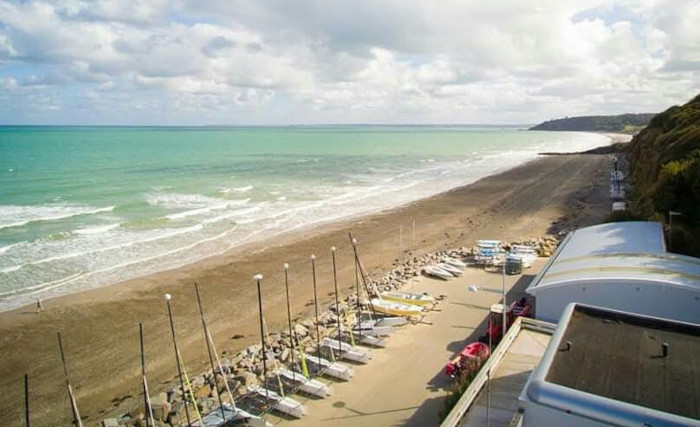
On this third day, the Costarmoricaine head back eastward for what is the longest leg of the raid. In the past, it has even ended at dusk due to lack of wind. In fact, there is often an intermediate finish at Loguivy, to bring the fleet together. Although part of the course is the same as the previous day's in reverse, this course is generally downwind and gives you the opportunity to sail relatively far off the coast to Les Héaux-de-Bréhat. After passing the foot of the Plouha cliffs, the highest in Brittany, the Formule 18s will arrive this year in Plérin, where they will be welcomed by the Centre Nautique Municipal de Plérin, a partner of the event for several years. In previous years, this stage ended in St-Quay-Portrieux, the leg is 5nm longer.
- 08:00: Breakfast in a restaurant at Trestraou.
- 11:00: Departure in front of the beach of Trestraou, at the foot of the semaphore.
- Stop at Plérin, right behind the Pointe de Pordic.
- The van will be on the parking lot above the beach at
CNMP . Check-in and collation. - Shower and toilets at CNMP.
- 19:00: Dinner at CNMP.
Course
| # | Symb. | Description | Left on... | dprev(nm) | dtot(nm) | Coordinates | dtot(km) | Estimated time |
| 1 |  | Start line In front Trestraou beach. | 0.0 | 0.0 | 48° 49.964' N 3° 27.814' W(GP) | 0.0 | ||
| 2 |  | La Fronde Starboard side buoy | Starboard | 1.2 | 1.2 | 48° 49.867' N 3° 25.983' W(GP) | 2.2 | 11:00 - 11:40 |
| 3 |  | Pierre du Chenal Hazard tower | Port | 1.0 | 2.2 | 48° 49.283' N 3° 24.683' W(GP) | 4.2 | 11:10 - 11:50 |
| 4 |  | La Roche Guazer Port side buoy | Starboard | 3.4 | 5.6 | 48° 51.600' N 3° 20.967' W(GP) | 10.4 | 11:20 - 12:30 |
| 5 | | Basse Crublent Port side buoy | Starboard | 7.0 | 12.6 | 48° 54.267' N 3° 11.150' W(GP) | 23.4 | 12:00 - 14:00 |
| 6 |  | La Jument des Héaux North buoy | Starboard | 2.3 | 14.9 | 48° 55.333' N 3° 8.033' W(GP) | 27.7 | 12:10 - 14:20 |
| 7 |  | Les Héaux de Bréhat Lighthouse | Starboard | 2.1 | 17.0 | 48° 54.500' N 3° 5.183' W(GP) | 31.5 | 12:20 - 14:50 |
| 8 |  | La Moisie East mark tower | Starboard | 2.1 | 19.1 | 48° 53.833' N 3° 2.217' W(GP) | 35.3 | 12:30 - 15:10 |
| 9 |  | La Vieille du Tréou Starboard side tower | Starboard | 2.0 | 21.0 | 48° 52.000' N 3° 1.083' W(GP) | 39.0 | 12:40 - 15:40 |
| 10 |  | La Vieille de Loguivy West mark tower Gate with an organization boat. | Port | 3.0 | 24.0 | 48° 49.617' N 3° 3.850' W(GP) | 44.5 | 13:00 - 16:10 |
| 11 | | Cadenenou North buoy | Starboard | 3.2 | 27.2 | 48° 49.800' N 2° 59.067' W(GP) | 50.4 | 13:10 - 16:50 |
| 12 | | Men Gam East mark tower | Starboard | 0.3 | 27.5 | 48° 49.550' N 2° 58.750' W(GP) | 51.0 | 13:10 - 17:00 |
| 13 |  | La Cormorandière Tower | Starboard | 2.0 | 29.6 | 48° 48.200' N 2° 56.450' W(GP) | 54.7 | 13:20 - 17:20 |
| 14 | | Les Charpentiers East mark tower | Starboard | 0.4 | 30.0 | 48° 47.883' N 2° 56.017' W(GP) | 55.5 | 13:20 - 17:20 |
| 15 |  | Les Calemarguiers East buoy | Starboard | 1.2 | 31.2 | 48° 46.983' N 2° 54.850' W(GP) | 57.7 | 13:30 - 17:40 |
| 16 | | Basse St Brieuc East buoy | Starboard | 1.0 | 32.2 | 48° 46.250' N 2° 53.717' W(GP) | 59.7 | 13:40 - 17:50 |
| 17 | | Le Taureau Hazard tower Gate with an organization boat. | Port | 2.9 | 35.1 | 48° 43.550' N 2° 55.250' W(GP) | 65.0 | 13:50 - 18:30 |
| 18 | | Île Harbour Lighthouse | Port | 5.7 | 40.8 | 48° 40.000' N 2° 48.500' W(GP) | 75.6 | 14:20 - 19:30 |
| 19 | | Finish line East mark tower In front of Countess' beach, between East tower Les Moulières de Portrieux and a boat showing an orange flag. | 0.9 | 41.7 | 48° 39.250' N 2° 49.215' W(GP) | 77.2 | 14:20 - 19:50 |
Warning:Provided geographical coordinates may contain errors, we disclaim any liability in this case. Furthermore, there are obstacles to navigation between some consecutive marks so you must prepare your navigation by carefully referring to a marine navigation chart.
The city: Plérin
The town of Plérin, also known as Plérin sur Mer, is located at the head of the Baie de Saint Brieuc, immediately adjacent to the Port du Légué. Its coastline is made up of cliffs and beaches (notably Les Rosaires), while the town center lies on a plateau at an altitude of around 100 meters.
Useful links:
City of Plérin
Baie de Saint Brieuc tourism center
Centre Nautique Municipal de Plérin