 FR
FR
Your are looking at version prior 2025. Click here for the current version.
Date: On Saturday
Distance: 31 or 40 miles (58 or 74km)
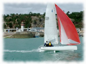
During this day, the Formula 18 catamarans leave from Saint-Quay-Portrieux to arrive in the harbor of Erquy, in front of the beach. Unlike on the first day, the boats will sail more close to the coasts of the bay of Saint Brieuc between the islet of Mauve and the Cap d'Erquy. They will cross the natural reserve of the Bay of Saint-Brieuc.
- 08:00: Breakfast in a restaurant on the harbor, Le Victoria.
- 11:00: Departure in front of the beach of Estran.
- Upon arrival, beach your boat at the top of the center beach at the end of Erquy Harbor, north of the swimming area. Be carefull, it is forbidden to navigate in this one.Then go to the Maison de la Mer for check-in, snack and find your luggage.
- 19:00: Diner in the classroom on the first floor of the Maison de la Mer (buffet).
Course
There are two possible routes for this leg, the choice is made to the mark "Le Légué" according to the conditions of navigation.
Alternative A :
| # | Symb. | Description | Left on... | dprev(nm) | dtot(nm) | Coordinates | dtot(km) | Estimated time |
| 1 |  | Start line In front the Estran beach. | 0.0 | 0.0 | 48° 38.570' N 2° 48.715' W(GP) | 0.0 | ||
| 2 |  | La Mauve Islet Turn around this small island. | Starboard | 4.5 | 4.5 | 48° 42.183' N 2° 52.783' W(GP) | 8.4 | 11:20 - 12:20 |
| 3 |  | Île Harbour Lighthouse | Port | 3.6 | 8.1 | 48° 40.000' N 2° 48.500' W(GP) | 15.0 | 11:40 - 13:00 |
| 4 |  | Herflux Tower | Port | 1.0 | 9.1 | 48° 39.067' N 2° 47.950' W(GP) | 16.8 | 11:40 - 13:10 |
| 5 |  | La Roselière South buoy | Port | 2.1 | 11.2 | 48° 37.300' N 2° 46.183' W(GP) | 20.8 | 11:50 - 13:40 |
| 6 |  | Le Légué Free water buoy Gate with an organization boat. If the boat shows a Charlie flag, apply the B alternative, otherwise this alternative applies. | Port | 4.5 | 15.7 | 48° 34.333' N 2° 41.150' W(GP) | 29.0 | 12:10 - 14:30 |
| 7 |  | Les Trois Pierres Port side buoy Gate with an organization boat. | Port | 8.8 | 24.5 | 48° 38.367' N 2° 29.367' W(GP) | 45.3 | 13:00 - 16:20 |
| 8 | | Basse du Courant South buoy | Port | 0.9 | 25.4 | 48° 39.233' N 2° 29.150' W(GP) | 46.9 | 13:00 - 16:30 |
| 9 | | Les Justières South buoy Gate with an organization boat. | Port | 2.2 | 27.6 | 48° 40.594' N 2° 26.493' W(GP) | 51.1 | 13:10 - 17:00 |
| 10 | | Basse du Courant South buoy | Starboard | 2.2 | 29.8 | 48° 39.233' N 2° 29.150' W(GP) | 55.2 | 13:20 - 17:20 |
| 11 | | Les Trois Pierres Port side buoy | Port | 0.9 | 30.7 | 48° 38.367' N 2° 29.367' W(GP) | 56.8 | 13:30 - 17:30 |
| 12 | | Finish line In front of the beach, in Erquy harbor. | 0.7 | 31.4 | 48° 37.988' N 2° 28.417' W(GP) | 58.2 | 13:30 - 17:40 |
Alternative B :
| # | Symb. | Description | Left on... | dprev(nm) | dtot(nm) | Coordinates | dtot(km) | Estimated time |
| 1 | | Start line In front the Estran beach. | 0.0 | 0.0 | 48° 38.570' N 2° 48.715' W(GP) | 0.0 | ||
| 2 | | La Mauve Islet Turn around this small island. | Starboard | 4.5 | 4.5 | 48° 42.183' N 2° 52.783' W(GP) | 8.4 | 11:20 - 12:20 |
| 3 | | Île Harbour Lighthouse | Port | 3.6 | 8.1 | 48° 40.000' N 2° 48.500' W(GP) | 15.0 | 11:40 - 13:00 |
| 4 | | Herflux Tower | Port | 1.0 | 9.1 | 48° 39.067' N 2° 47.950' W(GP) | 16.8 | 11:40 - 13:10 |
| 5 | | La Roselière South buoy | Port | 2.1 | 11.2 | 48° 37.300' N 2° 46.183' W(GP) | 20.8 | 11:50 - 13:40 |
| 6 | | Le Légué Free water buoy Gate with an organization boat. If the boat shows a Charlie flag, apply this alternative, otherwise alternative A applies. | Port | 4.5 | 15.7 | 48° 34.333' N 2° 41.150' W(GP) | 29.0 | 12:10 - 14:30 |
| 7 |  | Le Dahouët North buoy | Port | 3.9 | 19.5 | 48° 35.150' N 2° 35.450' W(GP) | 36.2 | 12:30 - 15:20 |
| 8 |  | Rohein West mark tower | Starboard | 4.0 | 23.5 | 48° 38.800' N 2° 37.767' W(GP) | 43.5 | 12:50 - 16:10 |
| 9 |  | Le Petit Léjon West buoy | Starboard | 3.0 | 26.5 | 48° 41.783' N 2° 37.583' W(GP) | 49.1 | 13:10 - 16:40 |
| 10 |  | L'Évette North mark tower | Starboard | 5.2 | 31.7 | 48° 38.517' N 2° 31.467' W(GP) | 58.7 | 13:30 - 17:50 |
| 11 | | Les Trois Pierres Port side buoy Gate with an organization boat. | Port | 1.4 | 33.1 | 48° 38.367' N 2° 29.367' W(GP) | 61.3 | 13:40 - 18:00 |
| 12 | | Basse du Courant South buoy | Port | 0.9 | 34.0 | 48° 39.233' N 2° 29.150' W(GP) | 62.9 | 13:40 - 18:10 |
| 13 | | Les Justières South buoy Gate with an organization boat. | Port | 2.2 | 36.2 | 48° 40.594' N 2° 26.493' W(GP) | 67.1 | 14:00 - 18:40 |
| 14 | | Basse du Courant South buoy | Starboard | 2.2 | 38.4 | 48° 39.233' N 2° 29.150' W(GP) | 71.2 | 14:10 - 19:10 |
| 15 | | Les Trois Pierres Port side buoy | Port | 0.9 | 39.3 | 48° 38.367' N 2° 29.367' W(GP) | 72.8 | 14:10 - 19:20 |
| 16 | | Finish line In front of the beach, in Erquy harbor, between a boat showing an orange flag and an inflatable yellow buoy. | 0.7 | 40.0 | 48° 37.988' N 2° 28.417' W(GP) | 74.2 | 14:20 - 19:30 |
Warning:Provided geographical coordinates may contain errors, we disclaim any liability in this case. Furthermore, there are obstacles to navigation between some consecutive marks so you must prepare your navigation by carefully referring to a marine navigation chart.
The Step City: Erquy
Number of inhabitants: 3568
Position: 48° 38'N, 2° 28'W
Area: 2646ha
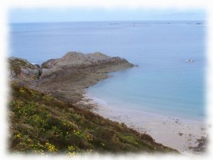
The harbor of Erquy is one of the main fishing ports for scallop of Côtes d'Armor. Cape of Erquy is composed of moors, pine woods and pink sandstone cliffs. There are old stone quarries (above the port) that were shipped by boat from the port.
Useful sites:
City of Erquy: http://www.ville-erquy.com/
Tourist Office: https://www.capderquy-valandre.com/