 FR
FR
Date: Sunday, August 2nd
Travel Distance: 26 miles (48km)
For this last leg of the long distance, the competitors will sail around the Cap Fréhel to go to Saint Cast and return to Erquy.
This leg is the shorter because this is the last day, but is important: more than once the title has changed hands for a few
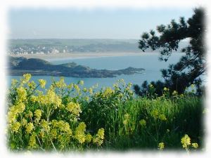
minutes lost or a mistake on this last round. You will have the opportunity to admire the two capes: Erquy and Fréhel.
You will be able to see the Saint Michel chapel on its islet, which reminds its big brother Mont Saint-Michel. Finally, under
the mark "The Laplace" lies the wreck of the frigate of the same name having sunk on September 16, 1950.
- 08:00: Breakfast at Table de Jeanne.
- 11:00: Departure
- Around 17:00: Award ceremony at the Maison de la Mer.
- The event will end around 17h30.
Course
Warning:Provided geographical coordinates may contain errors, we disclaim any liability in this case. Furthermore, there are obstacles to navigation between some consecutive marks so you must prepare your navigation by carefully referring to a marine navigation chart.
There are two possible routes for this leg, the choice is made to the mark "Le Laplace" according to the conditions of navigation.
| # | Symb. | Description | Left on... | dprev(nm) | dtot(nm) | Coordinates | dtot(km) | Estimated time |
| 1 |  | Start line in front of Erquy's harbor. | 0.0 | 0.0 | 48° 38.015' N 2° 29.037' W(GP) | 0.0 | ||
| 2 |  | Les Trois Pierres Port side buoy | Starboard | 0.4 | 0.4 | 48° 38.367' N 2° 29.367' W(GP) | 0.8 | 11:00 - 11:30 |
| 3 |  | Basse du Courant South buoy | Port | 0.9 | 1.3 | 48° 39.233' N 2° 29.150' W(GP) | 2.4 | 11:00 - 11:40 |
| 4 | | Les Justières South buoy | Port | 2.2 | 3.5 | 48° 40.594' N 2° 26.493' W(GP) | 6.5 | 11:10 - 12:10 |
| 5 |  | Pointe du Cap Fréhel Cap | Starboard | 5.0 | 8.5 | 48° 41.317' N 2° 19.083' W(GP) | 15.7 | 11:40 - 13:10 |
| 6 |  | Le Laplace Hazard buoy Gate with an organization boat. If the boat shows a Charlie flag, apply this alternative, otherwise alternative A applies. | Port | 2.4 | 10.8 | 48° 39.714' N 2° 16.450' W(GP) | 20.1 | 11:50 - 13:40 |
| 7 |  | Les Bourdinots East buoy Gate with an organization boat. | Port | 2.1 | 12.9 | 48° 39.017' N 2° 13.483' W(GP) | 23.9 | 12:00 - 14:00 |
| 8 | | Le Laplace Hazard buoy | Port | 2.1 | 15.0 | 48° 39.714' N 2° 16.450' W(GP) | 27.8 | 12:10 - 14:30 |
| 9 | | Pointe du Cap Fréhel Cap | Port | 2.4 | 17.4 | 48° 41.317' N 2° 19.083' W(GP) | 32.2 | 12:20 - 14:50 |
| 10 | | Les Justières South buoy | Starboard | 5.0 | 22.3 | 48° 40.594' N 2° 26.493' W(GP) | 41.4 | 12:50 - 15:50 |
| 11 | | Basse du Courant South buoy | Starboard | 2.2 | 24.6 | 48° 39.233' N 2° 29.150' W(GP) | 45.5 | 13:00 - 16:20 |
| 12 | | Les Trois Pierres Port side buoy | Port | 0.9 | 25.4 | 48° 38.367' N 2° 29.367' W(GP) | 47.1 | 13:00 - 16:30 |
| 13 | | Finish line In front of the beach, in Erquy harbor, between a boat showing an orange flag and an inflatable yellow buoy. | 0.7 | 26.2 | 48° 37.988' N 2° 28.417' W(GP) | 48.5 | 13:10 - 16:40 |
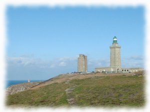
Cape Frehel
Position: 48° 37'N 2° 21'W
Cape Frehel is composed of cliffs at the top of which grows, as at Erquy, the moor. The current lighthouse of Cap Fréhel was inaugurated on July 1st, 1950. It is 30m high, so that it rises to 103m above sea level. Behind Cap Fréhel, is the castle of Fort the Latte, built in the 14th century. In 1954, it have been featured in the movie "The Vikings".
Fréhel website: www.pays-de-frehel.com/