


Date: On Thursday
Distance: 31 or 40 nm (57 or 73km)
During this second leg of the Costarmoricaine long distance, the Formula 18 catamarans leave from the Port-Clos in Bréhat to arrive in front of the beach of Trestraou in Perros-Guirec. They leave the shelter of the bay of Saint Brieuc, sail the mouth of the Trieux river, then meet the Héaux de Bréhat, one of the places of the region with the strongest tide currents. They then sail against the swell until the Sept-Îles (Seven Islands) of Perros-Guirec.
There are two possible routes for this leg, the choice is made to the mark "Pierre du Chenal" according to the conditions of navigation.
Alternative A :
| # | Symb. | Description | Left on... | dprev(nm) | dtot(nm) | Coordinates | dtot(km) | Estimated time |
| 1 |  | Start line In front of Arcouest. | 0.0 | 0.0 | 48° 49.765' N 3° 0.845' W(GP) | 0.0 | ||
| 2 |  | La Vieille de Loguivy West mark tower | Starboard | 2.0 | 2.0 | 48° 49.617' N 3° 3.850' W(GP) | 3.7 | 11:00 - 11:50 |
| 3 |  | La Vieille du Tréou Starboard side tower | Port | 3.0 | 5.0 | 48° 52.000' N 3° 1.083' W(GP) | 9.3 | 11:20 - 12:20 |
| 4 |  | La Moisie East mark tower | Port | 2.0 | 7.0 | 48° 53.833' N 3° 2.217' W(GP) | 12.9 | 11:30 - 12:50 |
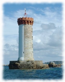
| 5 |  | Les Héaux de Bréhat Lighthouse | Port | 2.1 | 9.0 | 48° 54.500' N 3° 5.183' W(GP) | 16.8 | 11:40 - 13:10 |
| 6 |  | La Jument des Héaux North buoy Gate with an organization boat. | Port | 2.1 | 11.1 | 48° 55.333' N 3° 8.033' W(GP) | 20.6 | 11:50 - 13:40 |
| 7 |  | Basse Crublent Port side buoy | Port | 2.3 | 13.4 | 48° 54.267' N 3° 11.150' W(GP) | 24.9 | 12:00 - 14:10 |
| 8 | | La Roche Guazer Port side buoy Gate with an organization boat. | Port | 7.0 | 20.4 | 48° 51.600' N 3° 20.967' W(GP) | 37.8 | 12:40 - 15:30 |
| 9 |  | Pierre du Chenal Hazard tower If a boat of the organization shows a Charlie flag, variant B applies, otherwise this variant applies. | Starboard | 3.4 | 23.8 | 48° 49.283' N 3° 24.683' W(GP) | 44.1 | 12:50 - 16:10 |
| 10 |  | La Fronde Starboard side buoy | Port | 1.0 | 24.8 | 48° 49.867' N 3° 25.983' W(GP) | 46.0 | 13:00 - 16:20 |
| 11 |  | Bilzic Port side tower | Starboard | 0.4 | 25.2 | 48° 50.183' N 3° 25.717' W(GP) | 46.7 | 13:00 - 16:30 |
| 12 |  | Les Couillons de Tomé West buoy | Starboard | 0.7 | 25.9 | 48° 50.867' N 3° 25.667' W(GP) | 47.9 | 13:00 - 16:40 |
| 13 |  | Les Dervinis South buoy Gate with an organization boat. | Port | 1.9 | 27.7 | 48° 52.367' N 3° 27.333' W(GP) | 51.4 | 13:10 - 17:00 |
| 14 |  | La Horaine North mark tower | Port | 2.5 | 30.2 | 48° 49.883' N 3° 27.250' W(GP) | 56.0 | 13:30 - 17:30 |
| 15 | | Finish line In front of Trestraou beach, between a boat with an orange flag and an inflatable yellow buoy. | 0.8 | 31.0 | 48° 49.107' N 3° 27.335' W(GP) | 57.4 | 13:30 - 17:40 |
Alternative B :
| # | Symb. | Description | Left on... | dprev(nm) | dtot(nm) | Coordinates | dtot(km) | Estimated time |
| 1 | | Start line In front of Arcouest. | 0.0 | 0.0 | 48° 49.765' N 3° 0.845' W(GP) | 0.0 | ||
| 2 | | La Vieille de Loguivy West mark tower | Starboard | 2.0 | 2.0 | 48° 49.617' N 3° 3.850' W(GP) | 3.7 | 11:00 - 11:50 |
| 3 | | La Vieille du Tréou Starboard side tower | Port | 3.0 | 5.0 | 48° 52.000' N 3° 1.083' W(GP) | 9.3 | 11:20 - 12:20 |
| 4 | | La Moisie East mark tower | Port | 2.0 | 7.0 | 48° 53.833' N 3° 2.217' W(GP) | 12.9 | 11:30 - 12:50 |
| 5 | | Les Héaux de Bréhat Lighthouse | Port | 2.1 | 9.0 | 48° 54.500' N 3° 5.183' W(GP) | 16.8 | 11:40 - 13:10 |
| 6 | | La Jument des Héaux North buoy Gate with an organization boat. | Port | 2.1 | 11.1 | 48° 55.333' N 3° 8.033' W(GP) | 20.6 | 11:50 - 13:40 |
| 7 | | Basse Crublent Port side buoy | Port | 2.3 | 13.4 | 48° 54.267' N 3° 11.150' W(GP) | 24.9 | 12:00 - 14:10 |
| 8 | | La Roche Guazer Port side buoy Gate with an organization boat. | Port | 7.0 | 20.4 | 48° 51.600' N 3° 20.967' W(GP) | 37.8 | 12:40 - 15:30 |
| 9 | | Pierre du Chenal Hazard tower If a boat of the organization shows a Charlie flag, this variant applies, otherwise variant A applies. | Starboard | 3.4 | 23.8 | 48° 49.283' N 3° 24.683' W(GP) | 44.1 | 12:50 - 16:10 |
| 10 | | La Fronde Starboard side buoy | Port | 1.0 | 24.8 | 48° 49.867' N 3° 25.983' W(GP) | 46.0 | 13:00 - 16:20 |
| 11 | | Bilzic Port side tower | Starboard | 0.4 | 25.2 | 48° 50.183' N 3° 25.717' W(GP) | 46.7 | 13:00 - 16:30 |
| 12 | | Les Couillons de Tomé West buoy | Starboard | 0.7 | 25.9 | 48° 50.867' N 3° 25.667' W(GP) | 47.9 | 13:00 - 16:40 |
| 13 | | La Roche Guazer Port side buoy | Starboard | 3.2 | 29.1 | 48° 51.600' N 3° 20.967' W(GP) | 53.9 | 13:20 - 17:10 |
| 14 | | Pierre du Chenal Hazard tower | Starboard | 3.4 | 32.5 | 48° 49.283' N 3° 24.683' W(GP) | 60.1 | 13:40 - 17:50 |
| 15 | | La Fronde Starboard side buoy | Port | 1.0 | 33.5 | 48° 49.867' N 3° 25.983' W(GP) | 62.0 | 13:40 - 18:10 |
| 16 | | Bilzic Port side tower | Starboard | 0.4 | 33.9 | 48° 50.183' N 3° 25.717' W(GP) | 62.7 | 13:40 - 18:10 |
| 17 | | Les Couillons de Tomé West buoy | Starboard | 0.7 | 34.5 | 48° 50.867' N 3° 25.667' W(GP) | 64.0 | 13:50 - 18:20 |
| 18 | | Les Dervinis South buoy Gate with an organization boat. | Port | 1.9 | 36.4 | 48° 52.367' N 3° 27.333' W(GP) | 67.4 | 14:00 - 18:40 |
| 19 | | La Horaine North mark tower | Port | 2.5 | 38.9 | 48° 49.883' N 3° 27.250' W(GP) | 72.0 | 14:10 - 19:10 |
| 20 | | Finish line In front of Trestraou beach, between a boat with an orange flag and an inflatable yellow buoy. | 0.8 | 39.7 | 48° 49.107' N 3° 27.335' W(GP) | 73.5 | 14:10 - 19:20 |
Warning:Provided geographical coordinates may contain errors, we disclaim any liability in this case. Furthermore, there are obstacles to navigation between some consecutive marks so you must prepare your navigation by carefully referring to a marine navigation chart.
Number of inhabitants: 7288
Position: 48° 48'N 3° 26'W
Area: 1416ha
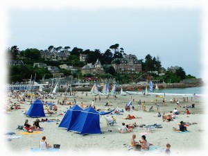
Perros-Guirec is located at the western end of our journey, in the heart of the pink granite coast. Arriving by sea, you can contemplate the archipelago of Sept-Îles (seven island) which hosts the largest colony of puffins, a small marine bird with a colorful beak, emblem of the city. We will stop at Trestraou which is one of the two sandy beaches of this seaside resort. The Grand Hotel is typical of the Art Deco style of the 1920s, the great time of development of sea bathing.
Useful links:
City of Perros-Guirec: http://www.perros-guirec.com/
Club de Voile de la Baie d'Erquy - Maison de la Mer - 22430 Erquy - France - Copy not allowed - CGV - About us - Updated on: 13/06/2022 00:05 CET