


Date: On Wednesday
Distance: 28nm (52km)
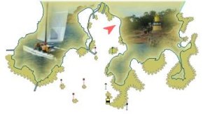
For this first leg, the Formula 18 catamarans start in front of Erquy's harbor and finish at the Men Joliguet tower at Bréhat island, on the other side of Saint Brieuc bay. The distance between those two points is only about 20nm, but the catamarans, to comply with their navigation zone must stay close to the coast.
| # | Symb. | Description | Left on... | dprev(nm) | dtot(nm) | Coordinates | dtot(km) | Estimated time |
| 1 |  | Start line in front of Erquy's harbor. | 0.0 | 0.0 | 48° 38.015' N 2° 29.037' W(GP) | 0.0 | ||
| 2 |  | L'Évette North mark tower | Port | 1.7 | 1.7 | 48° 38.517' N 2° 31.467' W(GP) | 3.1 | 11:00 - 11:50 |
| 3 |  | Rohein West mark tower | Starboard | 4.2 | 5.9 | 48° 38.800' N 2° 37.767' W(GP) | 10.9 | 11:20 - 12:40 |
| 4 |  | Basse Sud Caffa East buoy | Starboard | 3.6 | 9.5 | 48° 37.833' N 2° 43.067' W(GP) | 17.6 | 11:40 - 13:20 |
| 5 |  | La Roselière South buoy Gate with an organization boat. | Starboard | 2.1 | 11.7 | 48° 37.300' N 2° 46.183' W(GP) | 21.6 | 11:50 - 13:40 |
| 6 |  | Herflux Tower | Starboard | 2.1 | 13.8 | 48° 39.067' N 2° 47.950' W(GP) | 25.5 | 12:00 - 14:10 |
| 7 |  | Île Harbour Lighthouse | Starboard | 1.0 | 14.8 | 48° 40.000' N 2° 48.500' W(GP) | 27.4 | 12:10 - 14:20 |
| 8 | | Les Calemarguiers East buoy Gate with an organization boat. | Port | 8.2 | 22.9 | 48° 46.983' N 2° 54.850' W(GP) | 42.5 | 12:50 - 16:00 |
| 9 |  | Les Charpentiers East mark tower | Port | 1.2 | 24.1 | 48° 47.883' N 2° 56.017' W(GP) | 44.7 | 13:00 - 16:10 |
| 10 | | La Cormorandière Tower | Port | 0.4 | 24.5 | 48° 48.200' N 2° 56.450' W(GP) | 45.5 | 13:00 - 16:20 |
| 11 | | Men Gam East mark tower | Port | 2.0 | 26.6 | 48° 49.550' N 2° 58.750' W(GP) | 49.2 | 13:10 - 16:40 |
| 12 |  | Cadenenou North buoy | Port | 0.3 | 26.9 | 48° 49.800' N 2° 59.067' W(GP) | 49.8 | 13:10 - 16:50 |
| 13 | | Finish line West mark tower Finish line between the Men Joliguet tower and a boat displaying an orange flag. | 0.8 | 27.7 | 48° 50.117' N 3° 0.200' W(GP) | 51.3 | 13:10 - 17:00 |
Warning:Provided geographical coordinates may contain errors, we disclaim any liability in this case. Furthermore, there are obstacles to navigation between some consecutive marks so you must prepare your navigation by carefully referring to a marine navigation chart.
Number of inhabitants: 406
Position: 48°50'N 2°59'W
Length: 3,5km
Area: 318ha
The island of Bréhat, also called the island of flowers, is actually two large islands, connected by an isthmus, surrounded by many small islands. From the maritime point of view, you will find many things: the complete set of all possible navigation marks, lighthouses, a semaphore, a tide mill,... The Bréhat vessel company make it possible to come there from the point of Arcouest.
Some links:
Official website: http://www.iledebrehat.fr/
Tourist Office: http://www.brehat-infos.fr/
Les Vedettes de Bréhat: http://www.vedettesdebrehat.com/
Club de Voile de la Baie d'Erquy - Maison de la Mer - 22430 Erquy - France - Copy not allowed - CGV - About us - Updated on: 13/06/2022 00:05 CET